


Institute for Telecommunication Sciences / Research / Table Mountain / Research Activities
Portfolio of Table Mountain Research Activities
This webpage provides links to a few of the research projects that have been performed at Table Mountain. Scroll down for both a portfolio of research capabilities that leverage this Radio Quiet Zone and a guide from the 1960s.
2024 McMurdo Area Radio Noise Measurements and Analysis
 This NTIA Report presents high frequency (HF) band (3–30 MHz) radio noise power measurements at six locations in the McMurdo Station (MS), Antarctica (AQ), area and one location at the Black Island Telecommunication Facility (BITF) 32 km (20 mi) from MS. The primary purpose of the measurements is to compare MS and BITF radio noise powers so that HF radio system designers can assess the feasibility of relocating BITF air traffic control (ATC) and field party communication HF antennas and receivers to MS.
The measurement system was subjected to extensive characterization measurements prior to being used in Antarctica. The characterization measurements were conducted at the Table Mountain Radio Quiet Zone, which provided an ideal setting for testing noise measurement sensitivity.
NTIA Case Study: Adjacent-Band Coexistence Between 5G Base Station Transmitters and Air Traffic Control Radar Receivers

This NTIA Report from December 2024 describes a case study in radio spectrum coexistence between sensitive legacy safety-of-life air traffic control radar receivers and newly introduced, adjacent-spectrum 5G base station transmitters.
Figure 2 from the report (right) illustrates different forms of interference effects in radar station plan position indicator (PPI) screens. Blue wedge-shaped strobes and yellow ring-around circular patterns indicate individual drop-out zones; multiple strobes create what are called “rising sun” patterns.
NTIA/ITS, NTIA/OSM, the Federal Aviation Administration (FAA); the wireless carrier T-Mobile; and two 5G equipment manufacturers worked together to understand and resolve this coexistence challenge.
Measurements of 5G New Radio Spectral and Spatial Power Emissions for Radar Altimeter Interference Analysis
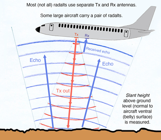
This NTIA Report from October 2022 investigates technical concerns about whether 5G transmitters can or will cause harmful radio interference to airborne radar (or radio) altimeter (radalt) receivers that operate in the band 4200–4400 MHz. When or if harmful interference occurs from 5G signals to radalt receivers, what is the
physical interference mechanism? At what limiting (coordination) distances, and in what directions, can harmful interference occur to radalt receivers from 5G transmitters?
Figure 7 from the report (right) shows the radar (transmitted waveforms with echo return) operation principle of radalts.
U.S. Geological Survey (USGS)
This website describes some of the work performed by the USGS at the Table Mountain Field Site. Table Mountain is one of 14 magnetic observatories operated across the United States and Territories by the USGS Geomagnetism Program. Magnetometer data are useful for a wide variety of research and operational applications, including mapping of the main field generated in the Earth’s deep interior, real-time monitoring of Earth’s space weather environment, and mitigation of magnetic storm interference and hazards.
Irregular Terrain Data

This Report from 1970 is the third of a four-part series that describes propagation experiment data collected from irregular terrain. The receiver tower was erected on the edge of the field site, where it could look out to the north and east across the plains. The experiment was specifically designed to simulate low-flying aircraft above the plains. Figure 8 from the report (right) shows the transmitting unit used for the lower frequency group (230, 410, and 751 MHz).
ITS used this data in 1982 to validate the Longley-Rice Irregular Terrain Model.
Portfolio of Research Capabilities
Historically, Table Mountain has supported a variety of radio science research projects, as detailed below.
Radiowave propagation measurements
- Validation of measurement system operation with both transmitter and receiver on field site allowing the investigation of both line-of-site and terrain-obstructed radio propagation paths

- Host propagation measurements such as long-haul, over the horizon troposcatter or line-of-site propagation paths. Longer duration measurements typically involve the location of the receive end of the links on site to reduce transmissions
- Host measurements of millimeter wave propagation and emissions characteristics of cellular systems
- Measurements of ground-wave propagation, such as research in support of DoD’s Joint Improvised-Threat Defeat Agency
Radar spectrum emissions criteria (RSEC) measurements
- Measurement of radar emissions required for NTIA Stage IV certification, which promotes improved electromagnetic compatibility between adjacent-band systems
End-to-end electromagnetic compatibility (EMC) measurements
- Real world testing of interactions between systems, with both systems operating on site
- The impact of system A’s transmissions is evaluated at System B’s receiver. Similarly, the impact of System B’s transmissions is evaluated at System A’s receiver.
Transmitter emissions characterization
- Measurements of the out-of-band emissions of 5G base stations to support EMC analyses are used particularly to quantify the interaction of a transmitter with systems in adjacent bands.
- Research into the time-varying nature of modern Advanced Antenna Systems employed in 5G+ networks which are used in aggregate interference models to support FCC Rulemakings
Satellite research
- Establishment of a Meteorological Satellite Earth Station research center that is a replica of NOAA L-Band systems used for spectrum sharing research
- Research into emerging non-terrestrial network (NTN)–related rulemakings. This involves the measurement of out-of-band emissions and received power from satellite transmitters for use in EMC models.
- Assessment of the health of aging satellites, such as GPS
Spectrum monitoring systems
- Table Mountain hosts NOAA’s Radiofrequency Interference Monitoring System (RFIMS) used to detect, classify, identify, and report on interference to L-Band Meteorological Satellite Earth Stations. This research informs NOAA’s decision-making on contractor performance and the suitability of RFIMS deployments
- Proving ground for commercial spectrum monitoring systems. Table Mountain is slated to host a system that will serve as a “digital twin” for one that the National Science Foundation plans to deploy at Antarctic research facilities, i.e., McMurdo Station, Black Island, and the South Pole.
Antenna characterization
- Measuring the radiation patterns of antennas mounted on vehicles as a function of azimuth using the vehicle-sized turntable used to. This is used to verify proper antenna placement to achieve desired patterns for research purposes on mobile test vehicles and for design of antennas used on DoD IED jammers
History
The web pages linked below reproduce a 1966 guide to the Table Mountain Field Site. At the time, ITS was called the Institute for Telecommunication Sciences and Aeronomy (ITSA). These five pages describe the ITSA electromagnetic research and the Table Mountain Field Site facilities.
Chapter 2: Ionospheric Telecommunications Laboratory
Chapter 3: Tropospheric Telecommunications Laboratory